
Oahu Moiliili Karst Formation
Many residents of the Moiliili area are unaware that just a couple meters
below their feet, cars, houses, and businesses lies a truly amazing formation.
The Moiliili karst formation is not only a “natural laboratory for
a largely unstudied groundwater zone,” but also important is the
“integration of drainage and economic importance” (Halliday
1998:145). The importance of the karst is paired with the incredible beauty
and wonder it holds beneath the earth’s surface. 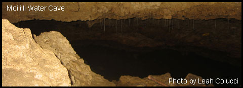


During the Pleistocene Sangamon Interglacial Stage, the sea level was more than 25 feet higher than its present level. This period of sea level elevation is responsible for the deposit of fossil reef limestone in southern coastal Oahu. According to Chester Lao of the Honolulu Board of Water Supply: “The limestone is composed of detritus, calcareous sand, reef dwelling organisms, and especially coralline algae” (Lao: pers comm.). After the Pleistocene interglacial stage, the sea retreated and left the fossil reef “miles inland of the present shoreline” (Lao: pers comm.). The weathering and erosion of Oahu’s dormant volcanoes, the Waianae and Koolau, paired with the rise and retrieval of the sea level resulted in the formation of “interbedded marine and terrestrial deposits” (Lao: n.d.).
It is located down slope from Manoa Valley underneath a bustling area of Moiliili. The lower edge is located at the intersection of University Avenue and Kapiolani Boulevard. According to William Halliday, “the wide upslope section of this karst is centered around the intersection of University Avenue and South King Street, down slope from the University Avenue interchange of “Interstate” Highway H-1.” (Halliday, 1998: 141). While the Manoa Stream has been diverted from its original course by lava flow, and it has been suggested that the cave system was part of the original channel of the stream (Halliday 1998). Another possibility Halliday (1998: 142) discusses is that “it formed in the shallow phreatic zone beneath that stream where flow velocity and, hence, dissolution would be expected to be greatest.” The environment above the karst is highly urbanized, containing busy streets, apartment buildings, and businesses. The consequences of such urbanization are evident. Before damages due to urbanization and cave-ins, the Moiliili Karst contained a 0.75 km cave that seemed to be a single connected structure (Halliday, 1997:97). The Moiliili Water Cave is the only formation still in tact today. In some areas, the cave is approximated to be as high as ten feet, and have depth of up to five feet in areas (Watanabe 1996).
Moiliii Karst Video
History of Moiliili Karst
The Karst was an integral part of the economy and world above it. There were several ponds that were fed by karsic springs. One was located west of University Avenue, upslope of Beretania Street. The Kanewai underground pond was important to Hawaiian culture, because its water was said to have healing properties. There was also an implication of a connection from the cave to the ocean due to a legend about fish in the caves hearing the fishermen’s plans and swimming out to tell the ocean fish (Army: 9). Another important spring fed pond was the Hausten (formerly Kumulae) pond. Originally the pond was a favorite of Queen Kamamalu (sister of Kamehameha IV and V). The pond served as an enjoyable picnic site for the Queen and her brothers. Hawaiian royalty loved swimming in the ponds, which were also said to have healing powers (Willows Flyer: Appendix A). The pond became the site of the Willows restaurant, and served as an attraction to customers. It was stocked with koi, which interbred with the existing fish creating a school of colorful fish (Halliday 1998).
The 1934 Dewatering
In 1934, a construction endeavor downslope struck a master conduit of the karst. This caused massive water drainage of the upslope area (Halliday: 1998). According to William Halliday (1998:143), “for more than four months, an average of 3.8 x 10⁷ L was pumped daily before the hole could be sealed and construction resumed.” The total amount pumped before the leak could be sealed was greater that one billion gallons of water (Halliday 1997). “The pumped water contained 25% of the chloride content of the ocean,” thus indicating retrograde flow from the ocean (Halliday 1998:144).
The lowering of the water table has had several consequences on the surrounding area. The dramatic changes in the karst from before 1934 to present time are a result of the dewatering. There is assumed to have been considerable economic loss as sidewalks split, water and gas mains ruptured, trees sank, and houses rose and settled (Halliday 1998). The spring feed ponds vanished within 24 hours, taking some fish into the karst, while leaving others stranded. There have been several instances of collapses since the dewatering. One instance involves the Standard Trading store falling through the ground into the karst below it (Watanabe 1996). Another instance involves the emergence of a large cavern downslope from the King-University intersection. Some fish that disappeared from the Hausten Pond were seen there (Halliday 1998).
The leak was repaired, but had changed the karst forever. Several spots
in the formation were deliberately filled, with no consideration of the
organisms within. The change in the water table also had consequences
for the Willows Restaurant. The pond had to be lined with concrete, and
the willow trees wilted (Halliday 1998). The restaurant lost much of its
appeal at the time, but has since been restored. The cave-ins greatly
reduced the size of the cave network, and changed access to the underground.
The University of Hawaii Quarry was destroyed to create athletic facilities
and a parking structure. Most surface karstic formations have been destroyed,
and the Water Cave is the only place where bare limestone can be seen.
It is enterable by only by a sewer grate, and despite the impacts of human
intrusion, “construction fill, metal pilings, and trash swept into
the system by floodwaters,” the cave has been able to retain its
cool, clear water and beautiful landscape (Army: 2003).